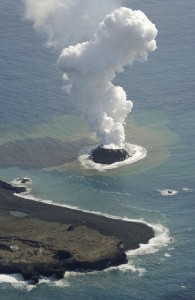
A huge volcanic eruption has created a new island in Japan’s Ogasawara Archipelago, just short of 1,000 km to the south of Tokyo.
Located in the Ogasawara Archipelago, some 1000 km to the south of Tokyo, the 200 meter diameter islet looks set to become the latest island to join this 30-strong group of tropical and sub-tropical islands.
Experts are as yet undecided as to whether the islet will become a permanent fixture on the map, with experienced volcanologist Hiroshi Oto warning that the fledgling island could easily be eroded away.
Whilst quick to welcome the potential for more territory, Japan’s chief cabinet secretary, Yoshihide Suga, also exercised caution when ask to comment on the island, citing previous examples of lava-borne islands disappearing as quickly as they had form.
Located within the so-called “Ring of Fire” – a near-continuous series of oceanic trenches, volcanic arcs and volcanic belts responsible for over 75% of the world’s volcanoes – the birth of this new islet was captured by television crews on Thursday, with thick plumes of smoke, ash and rocks exploding from a crater just of the coast of Nishinoshima.
The last recorded eruptions in the region were in the mid-1970s, with much of the activity emerging almost ten thousand meters below sea-level, at the site of the Izu-Bonin Trench. A particularly volatile hotbed of volcanic activity; the Izu-Bonin Trench is also responsible for the Izu Islands as well as the rest of the Ogasawara Islands.
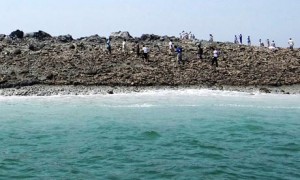
The creation of this islet comes is the second time in as many months that an island has been formed due to seismic activity. As recently as September this year, a new outcrop of land was formed in the Arabian Sea after a deadly earthquake rocked the Gwadar region of southern Pakistan.
Measuring in at 7.7 on the Richter scale, whilst it is clear that the emergence of this new island was triggered by the earthquake, the precise origins are a mystery, with seismologists unable to agree on whether the seismic shaking triggered an outpouring of mud from the seabed or whether a part of the shore was dramatically lifted as the quake hit.
Seismic activity is the most common way for the Earth to create islands. According to Iain Stewart, a professor of geoscience communication at England’s Plymouth University, one of the first accounts of islands being formed in this manner came from evolutionary pioneer Charles Darwin, who witnessed a huge earthquake hit the coast of Chile. Darwin’s account details how the coastline was thrust a few meters upwards, stranding foreshores and creating islands.


