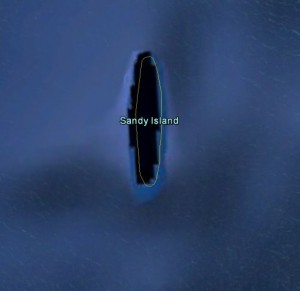
A team of Australian scientists were in for quite a shock when they went searching for a well-charted island in the middle of the Coral Sea.
Approximately halfway between Australia and France’s territory of New Caledonia sits Sandy Island, a South Pacific paradise that one can only assume is lush with swaying palms and fringed by pristine beaches. The island is easily located on Google Earth, is featured in numerous world atlases and maps, and despite its far-flung local, it appears to be a familiar landmark to many mariners. The only problem is this: Sandy Island doesn’t actually seem to exist.
Also Called “Sable Island” in the Times Atlas of the World, this phantom isle caught the attention of a geological survey crew out of Australia. The RV Southern Surveyor, the research ship of the country’s Marine National Facility, was on a 25-day tour of the Coral Sea region when the team’s suspicions were aroused by the extreme sea depth shown in their navigational charts – right where maps had placed the vast island. The team decided to find out if the island actually existed, and wound up sailing right through it.
According to geologist Dr. Maria Seton of the University of Sydney, led the expedition aboard the Southern Surveyor, the survey crew did not anticipate that the island would prove so elusive. “It’s on Google Earth and other maps so we went to check and there was no island. We’re really puzzled. It’s quite bizarre,” she said to the Associated Free Press. “How did it find its way onto the maps? We just don’t know, but we plan to follow up and find out.”
Recent media reports have suggested plenty of reasons for the missing island, ranging from the absurd to disappointingly dull. Potential solutions to the mystery have included global warming, a CIA conspiracy, or the inclusion of an intentional red herring so mapmakers could spot stolen data.
Alas, the most reasonable sounding explanation for is, of course, the ever-present “human error”. In this case, the transfer of hard-copy maps to a digital file could have led to the mistake, and given rise to what may become an internet legend – the mysterious “Mary Celeste” Island of the Coral Sea.
Read more about this story: Yahoo News


