Part three of a factual series about the Geology of New Zealand’s Fascinating Island Group – the Marlborough Sound (translated from a report produced by Dr Firouz Vladi, geologist)
(Image Copyright Farhad Vladi)
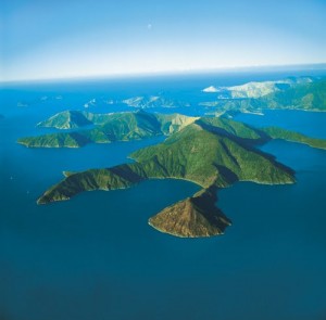
The Physiography of the Marlborough Sounds
The Marlborough Sounds and the mountain chains located directly to their south form a block of crust which inclines slightly towards the north. Directly to the east, the region borders on the Alpine Fault, a large lateral fault along which the fragments of New Zealand have so far slid some 500 km. And by “slid”, we really mean an earthquake-generating rumble.
The larger valleys and sounds of this area were formed along the strike of the variously weather-resistant rock formations as well as along faults in the earth’s crust (regardless of the type of rock). The slopes in this area are generally very steep.
During the Ice Age – in particular, during the closing 500,000 years – profound ground frost caused the geological structures located closely to the surface to be heavily weathered. Huge amounts of rubble slid down the slopes, filling up the valley and depressions as far as sea-level.
As such, it’s unusual to find evidence of stones here which haven’t been weathered.
The larger valley structures (and the rubble and gravel that filled them) sank below sea level because the block of crust upon which the Marlborough Sounds sits sinks to the north. The largest differences in height are up to 1,600m in the south and up to 1,000m in the north.
The Geological Formation of Forsyth Island
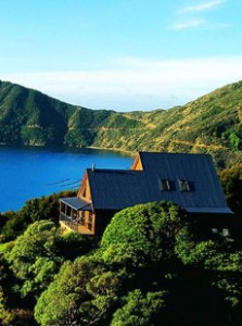
(The lodge on Forsyth Island)
The geological formations that later went on to form Forsyth Island – known as Marlborough Slate, Subzone II – were created after the Carboniferous Period, towards the end of the Paleaozoic Period. The geological formations of the Pohenui peninsula (Pelorus-Folge) are only slightly younger.
Two of Germany’s Harz Mountains – the Brocken (granite) and the Clausthaler Hochfläche (greywacke sandstone) – were formed during this era, as were the coalfields of the Rhein, the Ruhr and the Saar and the gypsum deposits of Nova Scotia.
The geological formation consists of greywacke, argillaceous slate and green slate – all of which were formed by deposits of fine sand and fine mineral turbidite (from clay particles) which – as assumed above – originated through the erosion of the Australian massifs.
As well as quartz sand, greywacke also includes considerable amounts of feldspar minerals, thus proving that they are formed via the erosion of granitic rocks (or rocks similar to granite). The accumulation of sediment on Forsyth Island reached a height of approximately 10,000 m – just more than the more recently-formed greywacke found on Pohuenui, which most likely originates from the Upper Carboniferous period. The geological formations on both islands are therefore up to 300 million years old.
After the erosion, the geological formations folded due to a lateral compression (plate thrust). The sheer mass of this enormous amount of sediment, the folded layers were pulled deeper still into the earth’s crust, causing them to heat up. The increase in temperature (combined with the high pressure) led to a recrystallization of the mineralogical composition – a process known as metamorphosis. The geologists understand enough about the both the earlier folding process and the sedimentation process (including the implications and by-products of this) in order to reconstruct them.
The by-products created during the sedimentary deposition of grey wacke include the repeated deposition of volcanic tuff sediment (a type of rock made out of volcanic ash ejected during an eruption). The metamorphosis causes the sediment to form bands of chlorotic green slate – a dark green, pure clay silicate which is characterized by its magnesia, iron and absorbed water content.
The geological formation of the Pelorus Fault supports not only Pohenui, but also the northern point of Forsyth Island (see the section of geological map Bl. 14, Marlborough Sounds, Signature Epe). The Pelorus Fault consists of a large dark green-coloured greywacke and black clay shale (argillite) – both of which reach up to 10,000 m in size. Neither of them contains fossils, making it difficult to determine their age. The presence of fossilized Atomodesma mussels originating from the early Permian era (290-248 million years ago) the more recent layers have lead geologists to deduce that the rock formations here originate from the Upper Carboniferous era. A noticeable layer of red, volcanic argillaceous slate can be found closer to the geological layer boundary of the Marlborough Slate which opens up to Forsyth Island in the north-west. Another striking feature can be found towards the upper layer of the Pelorus Falut: a conglomerate of volcani ejecta which has been sintered together.
More recent geological formations have not been encountered. Geologic formations originating from the Triassic period and containing plant residues can be found in the broader surroundings. Based on these findings, geologists have deduced that a mountain-building process took place So far, however, these geologists have not been able to draw many conclusions. What happened in the Marlborough Sounds – i.e. in the Jurassic and the Cretaceous Periods – is still unknown. There are no remnants of fossils – neither stones, nor traces of fossils.
Sedimentary deposits from the Tertiary Era (65 – 1.8 million years ago) can be found towards the south west of the Marlborough Sounds, including some steeply projecting bituminous coal seams, similar to those in Nelson. Limestone and siliceous sandstone later appeared – but had already been involved in the folding processes and therefore – partly – had steep projections.
The last thing to mention is the large amount sediment generated through erosion caused during the big freeze in the Ice Age. During the glacial period 20,000 – 12,000 years ago, the world’s sea level was approximately 100m lower than now. The Marlborough Sounds were a connected area of land. As the sediment that slid down the steep slopes to fill the depressions (formerly large valley structures) between North and South Island, they also caused the slopes to become steeper still and expose their mantle rock. Around the Marlborough Sounds, the crust continues to sink towards the north even now, meaning Forsyth Island will gradually get smaller.